16.2 Activity: Visualizing Relationships Between Earthquakes, Volcanoes, and Plate Boundaries
Computer Instructions

Visualizing Relationships between Earthquakes, Volcanoes, and Plate Boundaries in the Western U.S. Using the EarthScope Jr. Data Tool
Part I
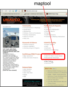
Starting at www.unavco.org
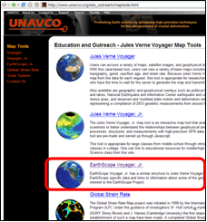
Click on maptools under the Education and Outreach section
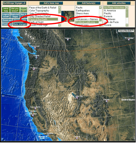
Click on EarthScope Voyager Jr. –The direct link is: http://jules.unavco.org/VoyagerJr/EarthScope A map of North America will load in several seconds.
Next, click on the map two times to obtain a zoom view of the western United States.
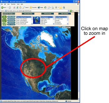
The map view should correspond to the map below and the following URL: http://jules.unavco.org/VoyagerJr/EarthScope?zoom=in;region=westernunitedstates_3_1
Orientation to the tool:
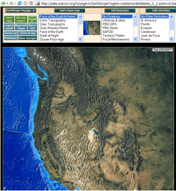
All learners: Select a base map.
Under the ‘Add a base map’ menu, click on ‘Face of the Earth & Relief’.
Click ‘Make changes’ once.
All learners: Add political boundaries to your map.
Under the ‘Add feature(s)’ menu, click on ‘Political, Lat/Long’.
Click ‘Make changes’ once.
In a few seconds, the map will reload with political boundaries, latitude and longitude lines, and major cities.
Earthquake Maps:
Important note: To highlight more than one feature at a time—in this case, political boundaries and earthquakes—you must hold the Ctrl key down on PCs and hold the Apple key down on Macs while you are selecting the additional feature(s).
Under the ‘Add feature(s)’ menu, select ‘Earthquakes’; Political, Lat/Long should stay highlighted.
Click ‘Make changes’ once. In a few seconds, the map will reload with the locations of earthquakes in bright green.
Study the map and fill out the worksheet under Part I.
Volcano Map
Important note: To highlight more than one feature at a time—in this case, political boundaries and volcanoes —you must hold the Ctrl key down on PCs and hold the Apple key down on Macs while you are selecting the additional feature(s).
Under the ‘Add feature(s)’ menu, select ‘Volcanoes’; Political, Lat/Long should stay highlighted.
Click ‘Make changes’ once. In a few seconds, the map will reload with the locations of volcanoes in red.
Study the map and fill out the worksheet under Part I.
Part II: Comparing Plate Motion Vector Maps Pacific Northwest and California
Return to the EarthScope Voyager Jr. tool.
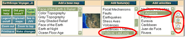
Under Add Features, click on ‘Political, Lat/Long’ and then click on ‘Make Changes’. This will remove the earthquakes and/or volcanoes icons.
Under the ‘Add velocities’ menu, select ‘N. America’ and ‘Obs’. Click ‘Make changes’ once. In a few seconds, the map will reload with plate motion vectors (arrows) in purple.
Study the plate motion vectors in the Pacific Northwest to the plate motion vectors in California and answer the questions on your worksheet.
Part III: Locating Plate Boundaries
Instructions
On your computer, remove plate motion vector data from your map by selecting ‘No Plate Velocities’.
Under the ‘Add feature(s)’ menu, select ‘Tectonic Plates’.
Click ‘Make changes’. After several seconds, a map illustrating the plate boundaries will appear.
Answer the final questions on your worksheet.
![]()